Ancient World Maps
Since man first scratched a map in the dirt and used stones to indicate landmarks, the history and development of maps has been an incredibly interesting topic. In this post, we are going to examine the history of world maps and see just how they have changed over thousands of years.

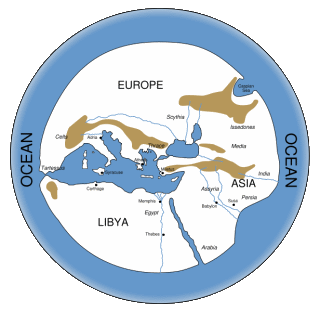
While man was certainly creating maps long before recorded history, we don’t really see a world map until somewhere between 700-500 BCE. This famous first world map is called the Imago Mundi (meaning Image of the World in Latin). This map was made on a clay tablet. It was broken over the years but reconstructed in the 20th Century and is on display in the British Museum in London, England. The concept of a circular, though flat world was born.
Soon after, Hecataeus of Miletus performed a survey of the known world, showing accurate outlines of landforms in the Mediterranean. This also included the Middle East and Western Asia. Representing a single, large landmass surrounded by water was an improvement on a map made by Anaximander, a Greek geographer.
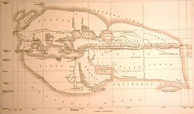
Around 250 BCE, Eratosthenes created a very much improved map which included information from the battles of Alexander the Great. It’s fascinating to see old names for places. In the lower right, the island of Taprobane, which is known today as Sri Lanka. This maps started to show concepts of latitude and longitude.
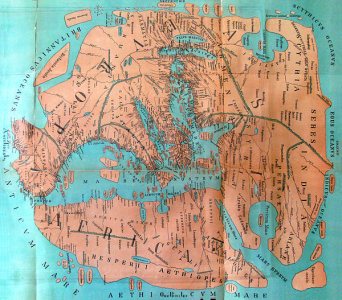
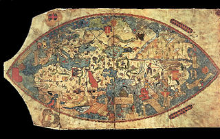
The last of the ancient map we will look at is the Pomponius map which was made around 40 BCE. This map shows a great amount of detail, identifying many islands and rivers. It reflects the range of exploration by the Roman Empire just before the beginning of the Common Era.
World Maps of the Middle Ages
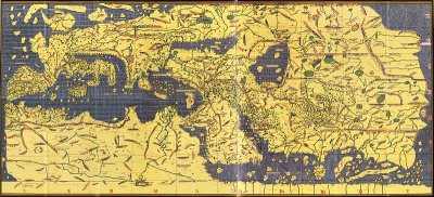
After a long period without much development in world maps, the famous Arab geographer, Muhammad al-Idrisi, created this map in 1154. It was part of a book which also contained descriptions of climate zones.
The Genoese was made just 35 years before Christopher Columbus set off on his voyage to what are the Americas. In this map, continents start to show more accurate proportions. No one knows exactly who made this map – such a mystery !
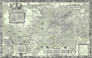
Gerardus Mercator created this map and with it the Mercator Projection, which shows lines of equal course. This projection, especially in its modern rendition, does distort size of land masses as it moves towards the poles. We’ll do a post on map projections later.
Modern World Maps
While there was continued great development in the accuracy of world maps, nothing can compare to what we have seen in the past 25 years with the advent of digital maps. We see greater detail of places than ever before. We can create three dimensional digital maps, and create maps with multiple layers of data! This combination of attributes makes modern maps so flexible and compelling and we can generate them in seconds.
I’m sure everyone has used Google Maps or Bing Maps or Open Street Maps. They are all very powerful mapping applications and people use them millions of times each day. They all have a slightly different look and feel but that means you get to choose what you like best. The following slide show shows an example of all three for the Washington, DC ares.
 Bing Maps


The following is an example of mapping the latitude and longitude of all of the zip codes in Spain ! This map took just minutes to create using Tableau Public Software after loading a table of zip codes.

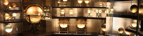
Globes !
When talking about world maps, we can’t forget globes. We have only examined flat maps, but globes have been a great way to view the entire world for centuries. Starting as far back as the 12th or 13th Century, geographers and cartographers started to produce globes. It wasn’t always popular to think of the world as round, but these scholars believed they were correct. The following slide show depicts some of the great globes ever made.
 Jost Burgi Globe 1594


To enjoy a great collection of globes, there is a wonderful Globe Museum in Vienna, Austria.
We hope you have enjoyed this trip throughout history to learn about the fascinating topic of world maps and globes.
Add comment