Welcome to Maps4Kids !
Helping children gain a greater understanding of the world through maps, geographic information and games.
Read More
The Maps4Kids Blog
In-depth articles on a wide range of topics from geography to geology to transportation (like bullet trains) to languages of the world!
Read MoreUS Map Explorer
A hands-on experience with visualizing US Geography using many different data points and visualization techniques. Created using Tableau !
Read MoreUS State Maps & Facts
Are you doing a report for school? Need to find a map of US states OR some information quickly and easily about one of our 50 states? Just click the map to see the state you are looking for !
Country Maps & Data
Dive into our treasure trove of country data to learn fun facts about the people, cultures, and flags that make each nation special.
Smart Links
Tons of other resources from other web sites to further your knowledge and understanding of the world.
Try Our New Maps4Kids App !
Maps4Kids is an educational geography app for children ages 6 through 12. It helps kids learn US states, world countries, maps, and key geography concepts through simple activities and exercises. The app includes interactive maps, quizzes, outline map practice, and topics like state birds and the Seven Wonders of the World. Designed for home and classroom use, Maps4Kids offers a structured, engaging way to build geography knowledge without ads, accounts, or data collection.
- State & Country Data
- Geography & Mapping Activities
- Quizzes And Games
- Get it in the App Store
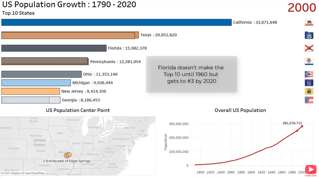
Our top video of the week !
This animated timeline of the United States population tells an exciting story of the movement of people over time as people moved South and West away from the original colonies.
- State Population Growth
- Overall United States Population
- Movement of the center of population of the USA
- See our Videos Page for more !
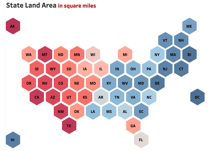
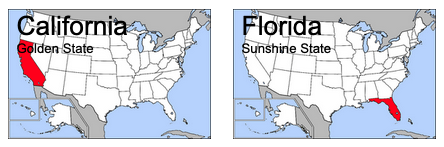
US Map Explorer
See the US in Layers of Geographic Data! Click on the different tabs to see how different types of maps can be used to represent different types of data. We explore everything from points of interest, to weather data, to national parks and rivers, and even look at how zip codes are distributed around the United States. Try all the different options in the drop downs on the tabs. Click on the image or here to check it out !
- Hottest and Coldest Places in the US
- States' Most Populated Cities
- States' Highest Points
- Cool map types like hex maps, overlay maps, density maps and spatial data
Outline Maps
We have a great collection of outline maps of all different types and regions. Some have labels, some don't ... some of the United States, some of the entire world ! An excellent free resource for all of your classroom or homeschooling projects. Find a us states map, us map of states, map of us states.
- US State with County Lines
- Canada & Canadian Provinces
- See our Outline Maps Page for more !
More About Maps4Kids
Maps4Kids is the place for students to find information on all aspects of Geography. Data they need for projects on states and countries is presented in a simple, easy to use format. Outline maps are available for students and teachers to download and use. There is a metric/standard calculator, lists of Fast Facts about all of the states, Top 10 lists, games of concentration, map puzzles, map quizzes, fascinating interactive maps created and published using Tableau Public, and much more !

How we assemble our data on the countries of the world
The World Factbook provides basic intelligence on the history, people, government, economy, energy, geography, environment, communications, transportation, military, terrorism, and transnational issues for 265 world entities.
- World Travel Facts
- Country Factsheets
- Flags of the World
- Country Comparisions
- See our Countries Page for more !
State Data Pages
Our most popular pages are the ones that provide detailed information on each of the 50 states.
- A detailed history of each state.
- Population, demographic and economic data.
- Full details on the geography of each state.
- See our States Page for more !
- Or use our Fast Facts Page for a sortable table of neat facts !
The History of Maps4Kids
Maps4Kids.com has been around since June of 2006 ! Many of the first children who used our website are now in their 20s and 30s. Imagine that !
My kids wanted a games site but I couldn't do that so I decided to use my coding skills and background as a Geographer to build Maps4Kids. Millions of visits later, we are still going strong.